


A blog…
Bannockburn’s Côte d’Or
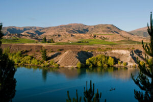
Burgundy’s famed Côte d’Or translates as the slope of gold. Well Bannockburn, unlike Burgundy, has a genuine golden history, and possibly nowhere in Bannockburn is as famous for gold as Cornish Point. Directly below it on the banks of the Clutha River, the Otago gold rush was started when Hartley and Riley found more gold than they could carry lying in rock hollows along the river bank. For the following half century mining continued at Cornish Point, ending with digging by massive floating dredges, which literally nibbled away a good part of the point itself. We’ve always known about that history, but we have other uses for the calcareous loess soils that remain there.
Recently, though, we were sent an intriguing bit of history, along with that proverbial cliché: a treasure map! It was part of a prospectus issued to raise money for a mining venture in 1928. The prospectus details how long ago, it was discovered that there was an ancient riverbed marking an earlier course followed by the Kawarau River. Now, the Kawarau is where the gold comes from, especially a tributary called the Shotover. The finds made by Hartley and Riley were gold that had been washed down the Kawarau and settled in hollows in the river bed, so the theory is that any old bed would be filled with similar washed gold. The dredges attacked both ends of this ancient bed and followed them as far in as they could, with much success, but finally reached the limit they could stretch to. The remaining section was unable to be mined as there was still a water flow deep in the soils that filled any tunnels that were dug. This prospectus was claiming that the new electric pumps that were available would be man enough to deal with the water, so the gold could be accessed. It appears that the prospectus was unsuccessful and no mining took place.
The map is pretty clear exactly where this old river bed runs and it is right through the middle of the vineyard. I won’t give details as we don’t need amateur spade enthusiasts trying to interfere with the vines! It would be futile to try anyway as the bed would run some 40 metres below current ground level.
But, when we created the vineyard we had to look for water so we could drill a bore. The experts (I remember that a diviner was involved) selected a suitable place and on drilling, a good water supply was found. That lies directly over where the map says the old riverbed lay and where the water still flowed deep underground.
So… what to do? I think we’ll leave well alone. We are winemakers not miners. But… if the world suddenly decides that they are bored with fine Pinot Noir… maybe we’ll have an option available!